Tag Archives: European Space Agency

European Space Agency (ESA)

Ten years of safer skies with Europe’s other satnav system

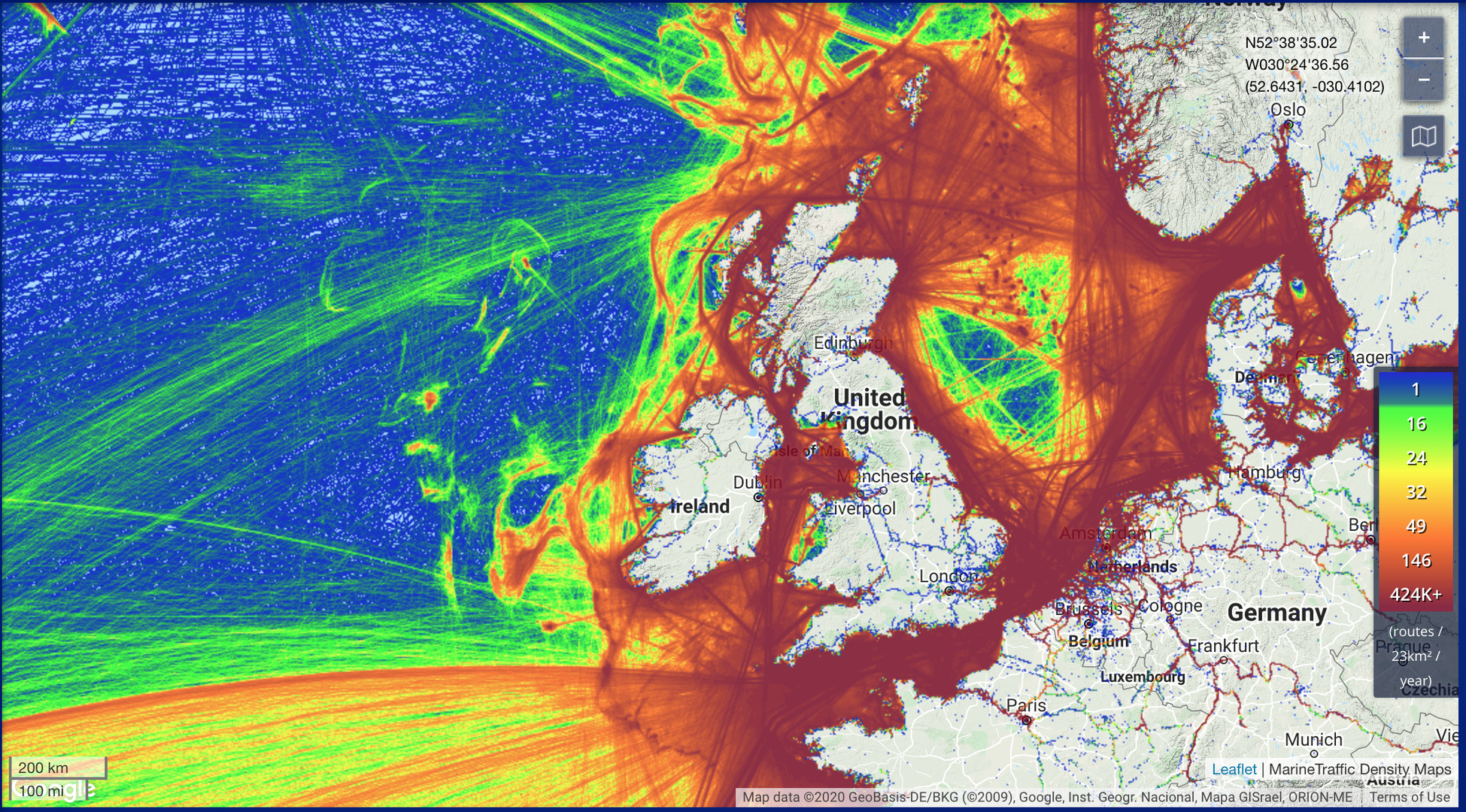
With 26 satellites in orbit and more than two billion receivers in use, Europe’s Galileo satellite navigation system has made a massive impact. But our continent has another satnav system that has been providing safety-of-life services for ten years now – chances are that you’ve benefited from it without noticing.

EGNOS

EGNOS

Its name is EGNOS, the European Geostationary Navigation Overlay Service. Transmitting signals from a duo of satellite transponders in geostationary orbit, EGNOS gives additional precision to US GPS signals – delivering an average precision of 1.5 metres over European territory, a tenfold improvement over un-augmented signals in the worst-case – and also confirmation of their ‘integrity’ – or reliability – through additional messaging identifying any residual errors. Read more…

Galileo OSNMA tests underway

Galileo has started testing Open Service Navigation Message Authentication (OSNMA) in the signal-in-space, allowing the first-ever OSNMA-protected position fix to be successfully computed. Testing will continue over the next months, ahead of a so-called “public observation” phase. This is the first-ever transmission of authentication features in open GNSS signals of a global navigation system.

OSNMA test signals are being broadcast by the Galileo constellation

OSNMA test signals are being broadcast by the Galileo constellation

The Galileo OSNMA is an authentication mechanism that allows GNSS receivers to verify the authenticity of GNSS information, making sure that the data they receive are indeed from Galileo and have not been modified in any way. Read more…

Satnav loss might shut down sea, warns ESA-backed study

Satellite navigation is precise, reliable and available continuously around the globe, but overreliance on it presents a clear and present danger to the smooth passage of maritime trade, concludes a major ESA-backed study.

Maritime traffic around British Isles

Maritime traffic around British Isles

With seaborne trade projected to double by 2030, the MarRINav project used a simulation approach to ‘stress test’ current navigation methods along highly trafficked shipping lanes around the British Isles. Every day more than 1.36 million tonnes of cargo arrive at major UK ports, guided predominantly by signals from space. Read more…

Galileo next-generation satellites on the horizon

With 26 satellites now in orbit and over 1.5 billion smartphones and devices worldwide receiving highly accurate navigation signals, Europe’s Galileo navigation system will soon become even better, ensuring quality services over the next decades.

Paul Verhoef, ESA Director of Navigation

Paul Verhoef, ESA Director of Navigation

Following the European Commission’s decision to accelerate development of Galileo Next Generation, ESA has asked European satellite manufacturers to submit bids for the first batch of the Galileo Second Generation (G2) satellites. The new spacecraft are expected to be launched in about four years. Read more…

Galileo now replying to SOS messages worldwide

As well as providing global navigation services, Europe’s Galileo satellite constellation is contributing to saving more than 2000 lives annually by relaying SOS messages to first responders. And from now on the satellites will reply to these messages, assuring people in danger that help is on the way.

Operation shark bait

This ESA-design ‘return link’ system, unique to Galileo, was declared operational this week, during the 12th European Space Conference in Belgium. The delivery time for the return link acknowledgement messages from initial emergency beacon activation is expected to be a couple of minutes in the majority of cases, up to 30 minutes maximum, depending primarily on the time it takes to detect and locate the alert. Read more…

ESA/JRC International Summer School on GNSS 2019

The 12th edition of the ESA/JRC International Summer School on GNSS 2019 will be held in Vila Nova de Cerveira, in the north of Portugal, from July 15-26.

Organized by the European Space Agency (ESA) and the Joint Research Centre (JRC), with the collaboration of Oporto University and several external sponsors, the school represents a unique chance for young satellite navigation researchers to get all the latest high-level information from renowned worldwide scientists and specialists, like the Director of the Galileo Programme and Navigation-Related Activities (D/NAV), Paul Verhoef. Read more…

Galileo app competition 2019 proves power of dual-frequency

Europe’s students and young researchers were challenged to design a smartphone app to take advantage of Galileo’s dual-frequency signals. The winning entries should soon be available to the public.

Satnav writing using single, dual frequency and precise correction signals

Satnav writing using single, dual frequency and precise correction signals

Run by ESA in collaboration with the European Global Navigation Satellite Systems Agency – GSA – plus the European Commission with the support of Google, a total of five teams made it to the final, which took place at ESA’s ESTEC technical heart in the Netherlands. Read more…