Author Archives: Galileo GNSS

Important milestones towards the new European Smart Tachograph

smart tachographNew Smart Tachograph security specifications have been prepared by the Joint Research Centre (JRC) for better enforcement of driving and resting times of heavy vehicle drivers to maximise road safety.

From 2019, all heavy vehicles must be equipped with a new Smart Tachograph, an improved version of the already existing digital tachograph which monitors and records the driving and resting times of professional drivers.

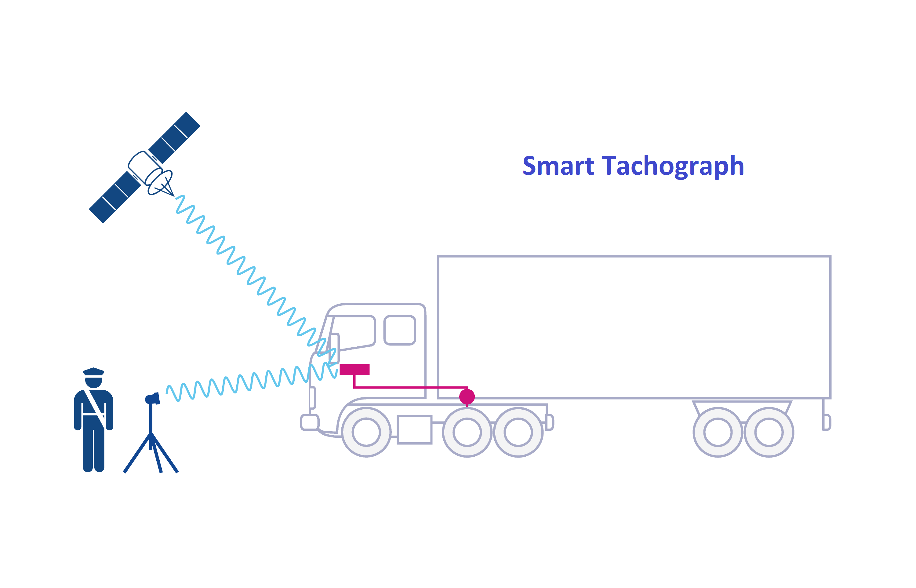
Smart Tachographs include a connection to the global navigation satellite system (“GNSS”) facility, a remote early detection communication facility, and an interface with intelligent transport systems, which will make it easier for authorities to track and identify potential offenders and detect fraud. Read more…

New Glonass satellites will be transmitting encoded signal

GLONASS satellites will be transmitting encoded signalNew GLONASS satellites will be transmitting a new encoded signal, the deputy CEO of Russia’s Roscosmos corporation, Mikhail Khailov, told a satellite navigation forum.

“At the moment the manufacturer keeps seven space satellites GLONASS-M in stock. Six will be transmitting the encoded navigation signal in L3,” he said.

Currently one GLONASS-M satellite and two new generation GLONASS-K satellites transmit the CDMA signal.

Russia to create highly elliptical orbit segment for Glonass

Russia to create highly elliptical orbit segment for GlonassThe work to create a highly elliptical orbit segment for Russia’s Glonass satellite navigation system will begin in 2019, CEO of Reshetnev Information Satellite Systems Company Nikolai Testoyedov said on Monday.

“The same concept envisages adjusting the Glonass target program and introducing a highly elliptical navigation segment of six satellites. This work will most likely start from 2019, if the concept is accepted and we are almost sure of that,” the chief executive was quoted as saying in the company’s corporate publication, Siberian Satellite. Read more…

The synergies between GNSS and Earth Observation

Synergies between GNSS and Earth Observation provide real-time information about the state of the Earth’s troposphereSpeaking at a dedicated session entitled “Applications: Earth Sciences and Geo-Information”, part of EUREF’s annual symposium, representatives of the mapping and surveying sector discussed the various synergies between GNSS and Earth Observation and their use for providing real-time information about the state of the Earth’s troposphere.

EUREF, the International Association of Geodesy (IAG) Reference Frame Sub-Commission for Europe, is dedicated to the definition, realisation and maintenance of the European Geodetic Reference Systems. Included in this mission is the development and maintenance of the EUREF GNSS Permanent Network (EPN), which is a ground-based GNSS infrastructure for scientific and practical applications in positioning and navigation. EUREF provides standards and guidelines to European National Mapping Authorities in order to harmonise the definition and adoption of national coordinate reference systems. Read more…

Interview with O. Montenbruck and P. Teunissen, editors of Handbook on GNSS

O. Montenbruck and P. TeunissenOliver Montenbruck (left picture), Head of the GNSS Technology and Navigation Group at DLR’s Space Operations Center and Peter Teunissen have edited an exhaustive reference work, the Springer Handbook of Global Navigation Satellite Systems, which brings together international experts to provide a state-of-the-art description of all facets of Global Navigation Satellite Systems.

Besides the obvious things, like navigation software in our cars and smart phones, which service or tools we use in our daily life, would not be possible without GNSS and would be deeply missed?
Peter Teunissen: GNSS radio occultation measurements provide important input for near-real-time weather forecast.
Oliver Montenbruck: Complex power grids and even stock exchanges would not work well without GNSS timing. Read more…

Two more satellites join Galileo service provision

Commissioning of two new Galileo satellitesThe European GNSS Agency (GSA), along with the European GNSS Service Centre (GSC), announce the commissioning of two additional satellites, bringing the total number of satellites available for the Galileo service provision to 18.

The GSA announced beginning of August the completion of in-orbit testing (IOT) of two new Galileo satellites, GSAT0212-SV ID 03- and GSAT0213-SV ID 04 -. Having passed all initial tests, the two satellites are now officially commissioned for operational use and are usable for the Galileo service provision (see NAGU 2017029 and NAGU 2017033). Read more…

Handbook on GNSS published by Springer

Springer Handbook of Global Navigation Satellite Systems

Springer Handbook of Global Navigation Satellite Systems

The Springer Handbook of Global Navigation Satellite Systems is now available.

Described as “A state-of-the-art description of GNSS as a key technology for science and society at large,” the 1,327-page tome is edited by Peter J.G. Teunissen and Oliver Montenbruck.

Teunissen is a professor of Geodesy and Satellite Navigation at Curtin University, Australia, and Delft University of Technology (TU Delft), the Netherlands.

Montenbruck is head of the GNSS Technology and Navigation Group at the DLR’s German Space Operations Center, Oberpfaffenhofen, and chair of the Multi-GNSS Working Group of the International GNSS Service. Read more…